Claremont Triangle Pilot Project: Message from Councillor C. Peart
TAKING A TEST DRIVE
Claremont Avenue is scheduled for full reconstruction next summer, from Sherbrooke Street northward to Marianopolis College. The Claremont Triangle, where NDG Avenue meets Claremont and Westmount Avenues, is also included in this project.
We can all agree that the reconstruction of Claremont Avenue is long overdue. It’s been 35 years since the road was last resurfaced and nearly 100 years since its underlying concrete base was first built. We might even uncover remnants of the old tram network, retired many decades ago.
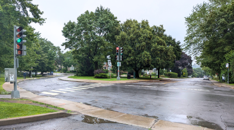
Earlier this month, Westmount launched a pilot project closing the one-way diagonal segment of NDG Avenue to vehicular traffic. In addition, the short segment of Claremont Avenue between Westmount and NDG Avenues will be temporarily converted to two oneway lanes, southbound only.
The advantage of a pilot project is that it is quick, inexpensive, and, most importantly, reversible. The objective of this pilot project is to measure the impact of an alternative configuration without the diagonal segment toward Westmount Avenue. The pilot is scheduled to run until November, providing enough time for users to adapt to the new setup. If needed, the trial period could be shortened.
Many of you might reasonably question why we would propose such a thing? Why would we ever think about removing the diagonal that has been there for as long as all of us can remember? I hope that I can provide you with some of the context and motivation for our decision-making.
Some of you may have heard me discuss the difference between reconstruction and other types of road work. In a full reconstruction, we go far beyond merely scraping and repaving the asphalt — as would be done in a basic repaving project. Instead, we demolish and remove the entire asphalt topping, the 6 to 8 inches of concrete slab beneath it, and all the underlying granular aggregates. We dig all the way down to the subsoil, leaving behind a blank slate upon which the contractors will rebuild the road and sidewalks from scratch.
So, seen another way, the question shouldn’t be, ‘Why would we take it out?’ For all intents and purposes, the road segment is already coming out. The better question would be, ‘Are we sure that we need to rebuild it?’. The pilot project should help us answer the question.
When we undertake larger projects, our planning guidelines encourage us to reassess infrastructure for safety, mobility, and resilience. While maintaining the status quo is an option, it should be challenged and revalidated before being rebuilt by default.
Consider the current context for safety and mobility. Vision Zero, a strategy aimed at eliminating all traffic fatalities and severe injuries while promoting safe, healthy, and equitable mobility, is a stated objective for this and future infrastructure projects.
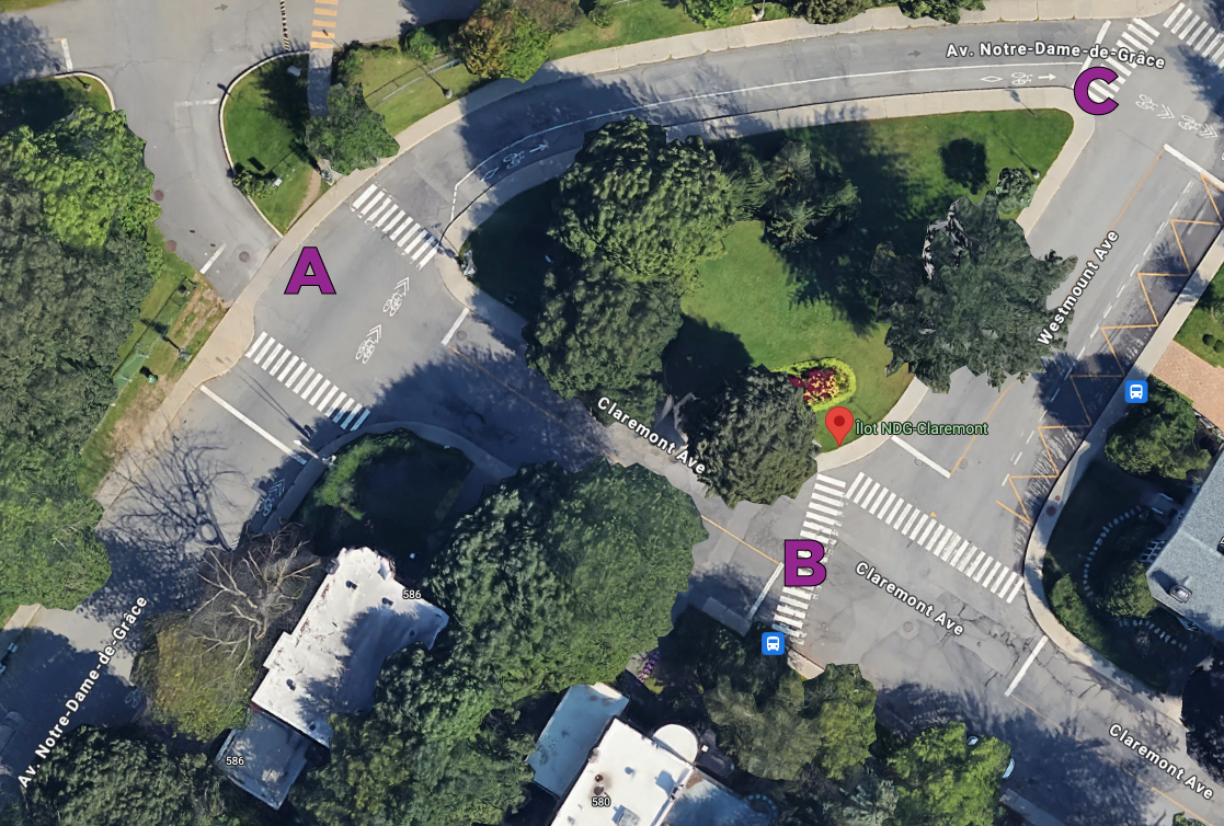
Most vehicular traffic enters the area eastbound on NDG Avenue at the top of the triangle, where it meets Claremont Avenue and Marianopolis College — let’s call this ‘Point A.’ Some vehicles turn south onto Claremont Avenue and then continue south at Westmount Avenue, which we’ll call ‘Point B.’ However, most vehicles proceed down NDG Avenue to its angled intersection with Westmount Avenue, referred to as ‘Point C.’
Marianopolis College generates significant traffic during peak periods, with frequent dropoffs and high pedestrian activity. Problematic behaviors from drivers, cyclists, and pedestrians, particularly at Point A, have led to confusion and friction. Additionally, higher speeds at Point C and the tendency for drivers to ignore or roll through stop signs at Points B and C are concerning. The pilot project aims to mitigate these risks.
Previously, drivers entering Westmount via NDG Avenue made their decision to travel south or east at Point A. By removing the ‘AC’ segment in the pilot project, this decision point is now relocated to Point B, but the choice option between southbound and eastbound travel remains unchanged.
Some have speculated that the pilot project seeks to reduce traffic through the triangle, but this was neither discussed nor targeted as an objective. Since the incoming volume remains the same and the outgoing travel options are unchanged, we do not expect any significant change in cumulative traffic volume along the new ‘ABC’ route.
Admittedly, the pilot project will require drivers to adjust their habits when navigating the area. We are also acutely aware of the inconvenience imposed on the single household with a driveway on the ‘AB’ segment of Claremont Avenue, which is being converted to oneway. Unfortunately, this is a constraint of the current road layout and is not planned as a feature of any potential permanent design. Given the possibility of a shared athletic field at Marianopolis, Council would resist any permanent solution that restricts direct access from Westmount.
In addition to prioritizing safety, Council considered both environmental and economic resilience.
The existing ‘AC’ diagonal segment covers over 500 square meters of road surface. With the increasing frequency and intensity of heavy rainfall events, effective stormwater management is a growing concern for Westmount. Could this impermeable road space be reimagined? Perhaps it could be repurposed as public space, green space, or for expanding our tree canopy.
Rebuilding the status quo involves significant capital costs, as well as ongoing operational expenses for snow removal, de-icing, street cleaning, repairs, and periodic repaving. Could these funds be better utilized elsewhere?
Your representatives on Council don’t claim to have all the answers — or even all the questions. We don’t always reach internal consensus, and this pilot project is no exception. We tasked our in-house planning and engineering teams with exploring a new configuration. External professionals were then brought in to review and build on their initial analysis. These experts have designed the pilot project to validate, inform, or challenge their simulations. A report will be published at the project’s conclusion.
In recent years, we’ve consulted with you more frequently and earlier in project timelines. Each successive project, from Lexington in 2022 to the upcoming Claremont and Forden projects in 2025, has incrementally expanded opportunities for resident participation. We’re proud of the progress we’ve made in engaging the community, but recognize the process is still evolving.
We hear the voices of opposition to the pilot project and encourage you to share your feedback via the online form on our Engage Westmount platform
(https://engage.www2.westmount.org). We also invite you to participate in the next phase of public consultation in September.
We once circled Summit Woods by car; now it’s a walking path.
We used to drive De Maisonneuve through Westmount Park; now it’s a bike and pedestrian path.
We accessed Côte-Saint-Antoine directly from Sherbrooke at Clarke; now the intersection is simplified.
We previously drove down Prince Albert at Sherbrooke; now it’s Prince Albert Square.
I suspect most wouldn’t want to revert to the old versions. A city evolves by rethinking its streets, and I believe this might offer another opportunity. Consider this counterfactual: “If the diagonal didn’t already exist, would anyone propose it?” Let’s give it a try and see how it works.
Conrad Peart
Councillor – District 4
Commissioner of Urban Planning and Architecture (Engineering and Infrastructure)
Member of the Planning Advisory Committee (PAC)
Member of the Finance and Administration Committee